Advanced GIS Services and Location Intelligence
We cover the entire GIS lifecycle, including data preparation, mapping, storage, processing, interpretation, and advanced spatial analysis. With years of domain expertise, our team develops tailored GIS workflows to address the unique challenges and objectives of each industry.
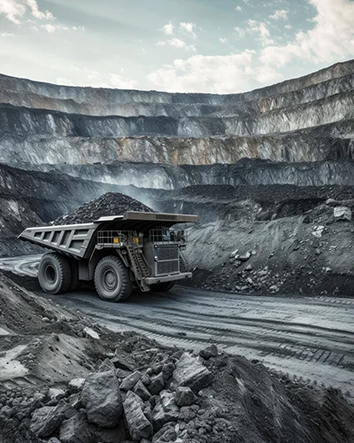
By leveraging a variety of data sources—satellite imagery, aerial photography, LiDAR, and terrain models—we deliver geospatial insights for applications such as mining volume estimation, powerline classification and vegetation clearance, route planning and traffic optimization in urban areas, and leakage detection with asset mapping in oil and gas.
Whether optimizing asset placement, managing complex networks, or supporting regulatory compliance, our GIS professionals ensure precision, efficiency, and clarity.

Advanced GIS Services and Location Intelligence
We cover the entire GIS lifecycle, including data preparation, mapping, storage, processing, interpretation, and advanced spatial analysis. With years of domain expertise, our team develops tailored GIS workflows to address the unique challenges and objectives of each industry.
By leveraging a variety of data sources—satellite imagery, aerial photography, LiDAR, and terrain models—we deliver geospatial insights for applications such as mining volume estimation, powerline classification and vegetation clearance, route planning and traffic optimization in urban areas, and leakage detection with asset mapping in oil and gas.
Whether optimizing asset placement, managing complex networks, or supporting regulatory compliance, our GIS professionals ensure precision, efficiency, and clarity.
Our Core Services

Digital Photogrammetry
Gain unmatched accuracy and detail with our LiDAR solutions—designed to capture the real world in 3D with precision down to the centimetre. Using advanced laser-based scanning, we provide high-resolution spatial data that supports smarter planning and faster decision-making.
From power lines and roads to railways and complex urban environments, our LiDAR services deliver clean, reliable data that overcomes the limits of traditional data processing. You get exact x-y-z coordinates, surface details, and intensity values that power next-level analysis and modeling.

LiDAR ( Light Detection and Ranging) Services
Gain unmatched accuracy and detail with our LiDAR solutions—designed to capture the real world in 3D with precision down to the centimetre. Using advanced laser-based scanning, we provide high-resolution spatial data that supports smarter planning and faster decision-making.
From power lines and roads to railways and complex urban environments, our LiDAR services deliver clean, reliable data that overcomes the limits of traditional data processing. You get exact x-y-z coordinates, surface details, and intensity values that power next-level analysis and modelling.

Ortho Photo
Unlock the power of true-to-life aerial, Satellite and drone photography with our industry-leading orthophoto services. Our advanced processing techniques eliminate the distortions caused by camera tilt, terrain variation, and lens imperfections, delivering georeferenced aerial images that accurately represent the world below.
Whether you’re mapping land use, monitoring infrastructure, or analyzing environmental changes, our services provide a reliable, geometrically-corrected foundation for all your needs. Forget about scale errors and warped perspectives – our orthophotos faithfully capture the ground as it is, empowering you to make better-informed decisions with confidence.

GIS Digital Twin
The evolution of 3D GIS and digital twin technology is transforming how we visualize and manage urban spaces. By creating accurate, real-time virtual models of physical environments, GIS Digital Twins offer enhanced clarity, control, and foresight—improving infrastructure planning, asset tracking, and operational efficiency.
A GIS-based Digital Twin is more than a 3D model—it’s a dynamic, data-driven replica of the real world. It integrates spatial data with behavioural, environmental, and operational inputs to simulate real-world conditions, predict outcomes, and support strategic decisions.

Annotation and Labelling
Annotation and labeling are fundamental processes in creating High-definition (HD) maps, ensuring accurate object recognition, scene understanding, and enhanced safety for autonomous vehicles.
Precise labelling and annotation play a crucial role in developing reliable HD maps. Advanced AI-powered annotation tools, combined with human expertise, ensure comprehensive data quality. Continuous validation, refinement, and integration of labelled data contribute to safer and more efficient autonomous driving systems. As the industry progresses, automated labelling solutions and collaborative annotation platforms will further streamline the HD map generation process, supporting the evolution of intelligent transportation systems.

Data Management
Unlock the full value of your geospatial data with Palni’s advanced Data Management Services. Using state-of-the-art GIS technologies, we convert raw datasets into accurate, high-resolution 2D and 3D visualizations. Whether you’re overseeing construction, mapping utilities, or performing environmental studies, our solutions deliver the clarity and precision needed to support confident decision-making.
With a strong track record across diverse industries, Palni empowers clients with intelligent mapping products that improve project visibility, enhance communication, and drive better outcomes.
Digital Photogrammetry
Gain unmatched accuracy and detail with our LiDAR solutions—designed to capture the real world in 3D with precision down to the centimetre. Using advanced laser-based scanning, we provide high-resolution spatial data that supports smarter planning and faster decision-making.
From power lines and roads to railways and complex urban environments, our LiDAR services deliver clean, reliable data that overcomes the limits of traditional data processing. You get exact x-y-z coordinates, surface details, and intensity values that power next-level analysis and modeling.
LiDAR ( Light Detection and Ranging) Services
Gain unmatched accuracy and detail with our LiDAR solutions—designed to capture the real world in 3D with precision down to the centimetre. Using advanced laser-based scanning, we provide high-resolution spatial data that supports smarter planning and faster decision-making.
From power lines and roads to railways and complex urban environments, our LiDAR services deliver clean, reliable data that overcomes the limits of traditional data processing. You get exact x-y-z coordinates, surface details, and intensity values that power next-level analysis and modelling.
Ortho Photo
Unlock the power of true-to-life aerial, Satellite and drone photography with our industry-leading orthophoto services. Our advanced processing techniques eliminate the distortions caused by camera tilt, terrain variation, and lens imperfections, delivering georeferenced aerial images that accurately represent the world below.
Whether you’re mapping land use, monitoring infrastructure, or analyzing environmental changes, our services provide a reliable, geometrically-corrected foundation for all your needs. Forget about scale errors and warped perspectives – our orthophotos faithfully capture the ground as it is, empowering you to make better-informed decisions with confidence.
GIS Digital Twin
The evolution of 3D GIS and digital twin technology is transforming how we visualize and manage urban spaces. By creating accurate, real-time virtual models of physical environments, GIS Digital Twins offer enhanced clarity, control, and foresight—improving infrastructure planning, asset tracking, and operational efficiency.
A GIS-based Digital Twin is more than a 3D model—it’s a dynamic, data-driven replica of the real world. It integrates spatial data with behavioural, environmental, and operational inputs to simulate real-world conditions, predict outcomes, and support strategic decisions.
Annotation and Labelling
Annotation and labeling are fundamental processes in creating High-definition (HD) maps, ensuring accurate object recognition, scene understanding, and enhanced safety for autonomous vehicles.
Precise labelling and annotation play a crucial role in developing reliable HD maps. Advanced AI-powered annotation tools, combined with human expertise, ensure comprehensive data quality. Continuous validation, refinement, and integration of labelled data contribute to safer and more efficient autonomous driving systems. As the industry progresses, automated labelling solutions and collaborative annotation platforms will further streamline the HD map generation process, supporting the evolution of intelligent transportation systems.
Data Management
Unlock the full value of your geospatial data with Palni’s advanced Data Management Services. Using state-of-the-art GIS technologies, we convert raw datasets into accurate, high-resolution 2D and 3D visualizations. Whether you’re overseeing construction, mapping utilities, or performing environmental studies, our solutions deliver the clarity and precision needed to support confident decision-making.
With a strong track record across diverse industries, Palni empowers clients with intelligent mapping products that improve project visibility, enhance communication, and drive better outcomes.
Your Trusted Partnerin Delivering Geospatial Precision at Scale

Precision-Driven Insights
High-accuracy geospatial mapping and analytics for confident, data-backed decisions.

Optimized Resource Planning
Smart geospatial models help allocate resources efficiently and reduce project costs.

Scalable Solutions
Flexible geospatial tools that grow with your projects—small or enterprise-scale.

Field-to-Cloud Integration
Seamless data flow from field crews to digital platforms for real-time visibility.

Smarter Collaboration
Cross-functional teams aligned with actionable geospatial intelligence at every step.
Who We Serve

Agriculture

Oil & Gas
Mining

Forestry
